
CLASSIFICATION AND DISTRIBUTION OF SOILS | Biogeography Optional for UPSC
CLASSIFICATION AND DISTRIBUTION OF SOILS | Biogeography Optional for UPSC

- It is very difficult to achieve a classification of soils that is both meaningful to the geographer and a farmer.
- Russian scientists took initial lead in the development of pedology (the science of soils)
- The Russian geologist, V.V. Dokuchaiev, related the development of soil to the climate and vegetation.
Two main types of classifications are used today:
- Genetic Classification: Those based on the origins of the soil.
- The Zonal System (Regional)
- Those based on the observable properties of the profile.
- USDA Soil Taxonomy
- British Soils Classification System
The Zonal System
- This was initially proposed by Russian pedologists. They recognized the strong relationship between climate, vegetation and soil zones.
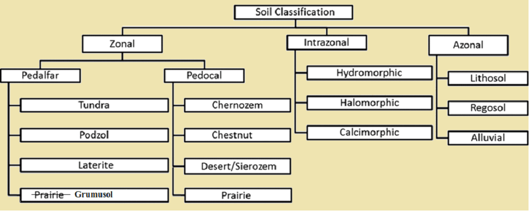
- C.F. Marbut presented a scheme of Comprehensive System of Soil Classification in 1938. He divided soils into three orders: Zonal soils, Intrazonal soils and Azonal soils.

Zonal soils
- These are well developed soils.
- These soils are result of interplay of climate and vegetation over a long period of time.
- These are developed under the good drainage conditions.
- These soils are characterised by full development of almost all the soil horizons.
Pedocal and Pedalfer
- These are groups of soils and subdivisions under the zonal soil order.
- However, these terms are generally used in academic texts only, and not in the present classification system.
- In 1935, Marbut defined a Pedocal-Pedalfer boundary, which lies at the 30 inches annual precipitation. (Evapotranspiration boundary)

Pedocal:
- Pedocal is formed in semiarid and arid regions.
- It is rich in calcium carbonate, and has low organic matter and humus.
- There is a thin A horizon. The leaching may form a cemented layer known as caliche in the B horizon.
Pedalfer:
- Pedalfer usually occurs in humid areas.
- It is composed of aluminum and iron oxides. Sesqui-oxides increase relative to silica during soil formation.
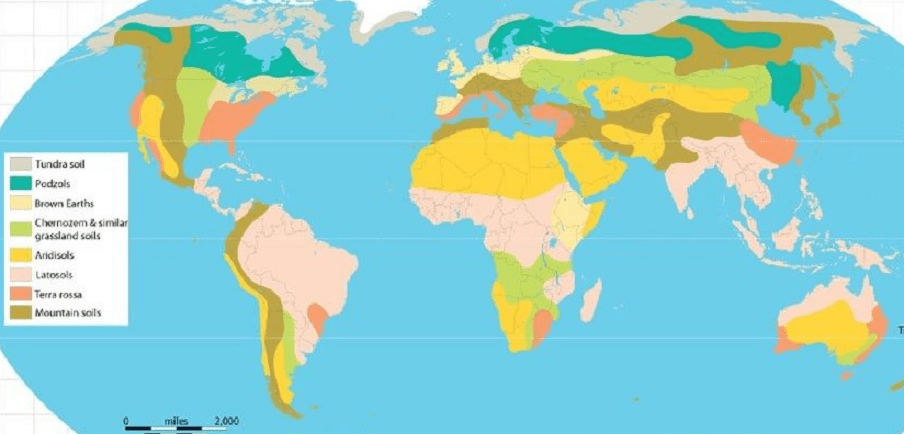
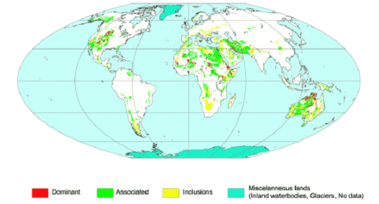
Distribution of Zonal Soils
The following zonal soils are distributed from the poles to equator:
- Tundra Soil
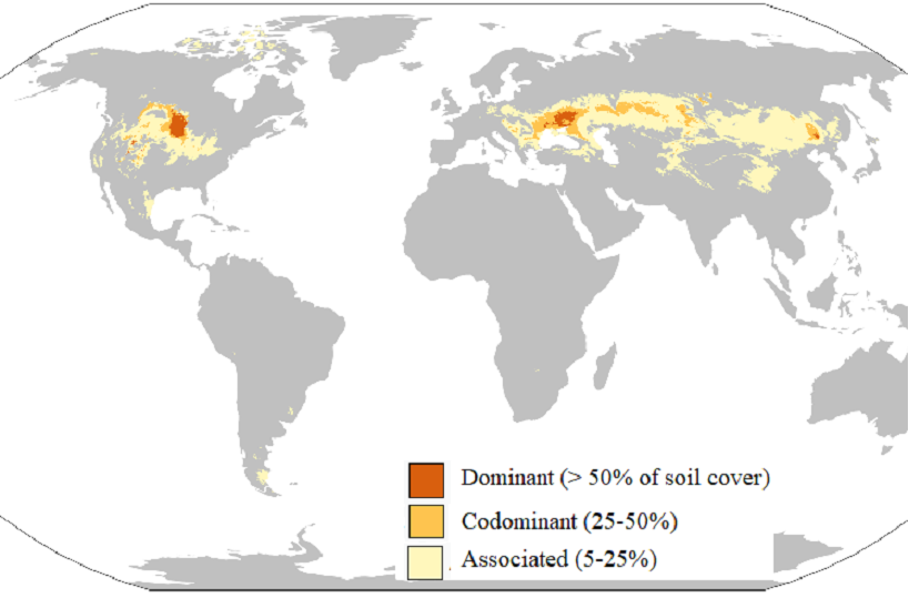
- Podzols (Taiga Soils or ash-soil)
- Chestnut and Chernozem Soil (Black Soils)
- Desert Soil मरुस्थलीय मिट्टी
- Ferralsol Soils (Lateritic Soils or oxisols)
Intrazonal soils
- These are well-developed soils formed where some local factor is dominant.
- These are formed in the areas of waterlogging and poor drainage.
- Regolith is endowed with high calcium carbonate. There is high content of soluble salts and sodium.
Azonal soils
- These are immature or poorly developed soils.
- Factors: Steep slope, renewal of soils, or the lack of time for development. Such situations occur in areas where fresh parent material is being deposited or exposed.
- These do not have well developed soil horizon. Rather, these have uniformity in soil profile.
- The form factor of these soils is not dependent on the local landform conditions. These are transported and deposited by various agents of erosion, like water, wind, glaciers, etc.
- Climatic factors do not have any major influence on soil formation.
Criticism of zonal concept
- The zonal soils of one climate may be found in another. For example, podzols are normally the zonal soils of cool continental climates, but those also occur in maritime and tropical areas.
- Azonal soils are not necessarily a reflection of the lack of time for development. These may be a result of local factors prevalent over a long period.
- The soil profiles do not always reflect the prevailing climate. These may have characteristics inherited from previous climates.
- The classification is primarily based on American experience. It does not properly accommodate the soils of the tropical regions.
- The classification is mainly based on the relation between soil properties and role of climate.
- There is more emphasis on undisturbed or virgin soils.
Evaluation
- Despite the limitations, the zonal system is one of the simpler frameworks for studying soil types.
- It is particularly suitable for describing soil types on a world scale.
2. USDA Soil Taxonomy
- It is a system of soil classification based on observed soil properties rather than genetic considerations.
- It is adopted by the US Department of Agriculture.
- Despite the difficult nomenclature, the system is becoming accepted in many parts of the world.
- The primary soil orders are not associated with particular climatic or geographic environments. Hence, it avoids some of the drawbacks of the zonal system.
Major Orders of the USDA Soil Taxonomy
| Order | Description (विवरण) | Equivalent Zonal System (समकक्ष ज़ोनल प्रणाली) |
|---|---|---|
| Entisols | Embryonic mineral soils | Azonal |
| Vertisols | Disturbed and invested clay soils | Grumusols |
| Inceptisols | Young soils with weakly developed horizons | Some brown earths |
| Aridisols | Saline and alkaline soils of deserts | Desert seirozems |
| Mollisols | Soft soils with thick organic-rich surface layer | Chernozems, Chestnus, Prairie |
| Spodosols | Leached acid soils with ashy B horizon | Podzols |
| Alfisols | Leached basic or slightly acidic soils with clay-enriched B horizons | Degraded chernozems |
| Ultisols | Deeply weathered, leached acid soils | |
| Oxisols | Very deeply weathered, highly leached | Ferralsols |
| Histosols | Organic soils | Bog soils |
Merits
The following characteristics make this scheme of more useful and advantageous than the other schemes:
- The classification is based on field and laboratory data.
- The classification pays more attention towards the practical aspects of the soils rather than the soil forming processes.
- Quantitative classification: The classes of soils have been strictly defined in terms of the characteristics of the soils.
- The soils modified by human activities have been given due weightage.
- It has wider scope to include all the unclassified soils.
- The classification gives a greater uniformity to the soil classification.
- The soils profiles is distinguished based on their surface horizon (epipedon) and sub-surface horizons.
Criticism
- One drawback is that some of the diagnostic properties are required to classify a particular soil type, which can only be revealed by detailed laboratory analysis.
- Very difficult nomenclature of Greek and Latin origin.
- More emphasis is given to laboratory data which may not be possible in many of the developing and under-developed countries.
Conclusion
This classification has many merits as a scientific and a rigorous basis, but it has not been adopted everywhere. However, it may remain one simple yet interesting soil classification. (M.I. Bradshaw, 1977).
3. British Soils Classification System It was proposed by B.W. Avery in 1956 for classifying British soils.
- This classification was built up for a specific purpose, and intended for a small area with a restricted soil range.
- The main emphasis is placed on the overall moisture status, with type of humus providing a basis for differentiation.
- This classification is proved useful for farmers, since it describes the drainage status and human type.
The classification
A. Well-drained terrestrial soils
- Raw mineral soils .
- Montane humus soils.
- Calcareous soil (including rendzinas).
- Leached mull soils (brown earths, grey-brown podzols).
- Podzolised (mor) soils.
B. Poorly drained hydromorphic soils
- Alluvial soils.
- Grey hydromorphic gleys.
- Gley-podzolic soils.
- Peaty alkaline soils.
- Peat bog (including blanket and raised bogs).
Classification of Zonal Soils

Tundra Soils
- The word "tundra" usually refers to the areas where the subsoil is permafrost, or permanently frozen soil.
- The tundra soil is rich in nitrogen and phosphorus. It also contains large amounts of biomass, that is stored as methane and carbon dioxide in the permafrost, making the tundra soil a carbon sink.
- As global warming heats the ecosystem and causes soil thawing, the permafrost carbon cycle accelerates and releases these soil-contained greenhouse gases into the atmosphere. It creates a feedback cycle that increases climate change.
- The great variations in the patterns of ground ice cause complex variations in these soils.
- It includes the soils of the mountains at higher elevations.
- In the areas of stable slope movement, the slow rate of plant decomposition results in the presence of a peaty layer.
- In areas of active slope movement, soils are inevitably thin.
- In the most extreme conditions where there is no plant growth, these soils are ahumic. Eg. the brown polar desert soils of the Antarctic.
- However, soils of the forested regions of the northern hemisphere are characterized by a thick dark organic A horizon.
Distribution
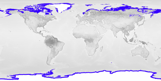
- Antarctic tundra is located in the southern hemisphere. It includes South Georgia and the South Sandwich Islands and the Kerguelen Islands.
- Arctic tundra is located in the northern hemisphere.
- Alpine tundra: It occurs in mountains worldwide. As the latitude of a location approaches the poles, the elevation for alpine tundra gets lower and merges with polar tundra.
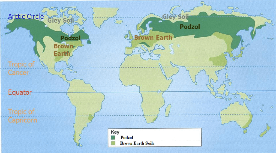
Podzols (Taiga Soils or ash-soil)
- Podzols are widespread in the cool climates immediately south of the tundra region.
- Podzol means "under-ash" and is derived from the Russian term "under-ashed soil". The term was first given by Vasily Dokuchaev.
- It refers to the common experience of Russian peasants of plowing an apparent under-layer of ash (in leached or E horizon) during first plowing of a virgin soil.
- Podzols can occur on almost any parent material, provided there is high precipitation.
- These are generally derived from quartz-rich sands and sandstone, or sedimentary debris from magmatic rocks.
- The cheluviation process produces soils with a bleached E horizon. Cheluviation is the leaching (eluviation) of chelates through soil.
- These are found typically in association with coniferous forest.
- Most Podzols are poor soils for agriculture due to the sandy portion, resulting in a low level of moisture and nutrients.
- However, well-drained loamy types can be very productive if lime and fertilizer are used.
- The best agricultural use of Podzols is for grazing.
- In Europe, podzols develop on heathland. Heath is an area of open land that is not used for farming, and that is often covered with rough grass and other wild plants.
Humus podzol:
- In some profiles, the humus is washed down the profile. It accumulates as a humus-enriched B horizon, which forms a humus podzol.
Iron podzol:
- There is a marked concentration of iron oxide at B horizon, which forms an iron podzol.
Gley podzol:
- Sometimes this takes the form of an iron-pan, interrupting drainage. It results in a gley podzol.

Distribution of Podzol
- Podzols are usually found under sclerophyllous woody vegetation. Sclerophyll is a type of vegetation that is adapted to long periods of dryness and heat.
- Podzols are most common in temperate and boreal zones of the Northern Hemisphere.
- These are also found temperate rainforests and tropical areas.
- In South America Podzols occur beneath Nothofagus betuloides forests in Tierra del Fuego.

Podzolization
- It is a soil formation process by which dissolved organic matter and ions of iron and aluminium, released through weathering of various minerals, form organo-mineral complexes (chelates). These are moved from the upper parts of the soil profile and deposit in the deeper parts of soil.
- Through this process, the eluvial horizon becomes bleached and of ash-grey colour.
- The complexes move with percolating water further down to illuviated horizons. They are commonly brown, red or black as they consist of sesqui-oxides and organic compounds.
- The podzolization is a typical soil formation process in Podzols.

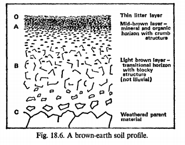
Brown Earth Soils
- These are mostly located between 35° and 55° north of the Equator. It is a zone of moderate temperature and moderate rainfall.
- The soils exhibit moderate leaching.
- The dispersed distribution of sesqui-oxides gives its brown colour.
- Humus is well distributed throughout the profile. It is less acidic than in podzols.
- Agriculture and vegetation: The most common vegetation types are deciduous woodland and grassland. Due to the reasonable natural fertility, large tracts of deciduous woodland are cut down, and now used for farming.
Distribution
- Brown earths are widespread in Britain, except in the highland areas.
- Western and central Europe
- Western and trans-Uralian Russia
- East coast of America
- Eastern Asia.
- Eastern Australia and New Zealand.
Chernozem Soils (Black soil)
- Chernozem is also called as black soil. These are found in steppe or prairie areas.
- Chestnut soils and prairie soils are considered part of it.
- Its dark colour is associated with base-rich mineral matrix. It contains a high percentage of humus (4% to 16%) and high percentages of phosphorus and ammonia compounds.
- It is very fertile soil. It produces high agricultural yields with its high moisture storage capacity.
- There is light rainfall in these areas, which leads to incomplete leaching and the formation of a calcium-rich horizon deep in the profile. Above this is a deep dark layer of soil.
- These have a well-developed crumb structure. The ideal parent material for this soil seems to be loess, which is widespread in the mid-west of North America, Russia and northern China.
Chestnut soils
- These occur on the arid side of the chernozem belt under a natural vegetation of low grass-steppe.
- Chestnut soils contain carbonates and, in most cases, gypsum in the lower part of the profile.
- The illuvial carbonate layer is closer to the surface than in chernozems and they have lowest organic content.
- Distribution: It is found in the Mediterranean climate regions.
- It is famous for the production of citrus fruits and supports a wide range of vegetation.
- Very fertile soil for the plantation crops.
Prairie soils
- These occupy the transition zone of increasing wetness between chernozems and forest brown earths.
Distribution
- There are two chernozem belts in the world.
- One is the Eurasian steppe which extends from Wallachian Plain and Moldavian Plain to northeast Ukraine across the Central Black Earth Region of Russia, to Siberia.
- The other one stretches from the Canadian Prairies through the Great Plains of USA as far south as Kansas.
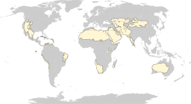
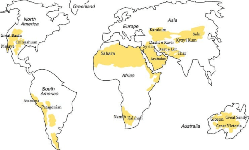
Sierozems (Desert soil or Aridisol)
- Desert soil is also as called Sierozem soil.
- It is rich in soluble salts but contains varying percentages of calcium carbonate. The soil is very poor in nitrogen and humus.
- These can be regarded as extreme forms of chestnut soils, in which lime and gypsum come even nearer to the surface because of upward capillary action.
- Most of the plants are adapted to arid conditions. Hence, there is little leaf fall, hence low organic matter.
- However, when irrigated, these soils can be very fertile, because of their high base status. Water deficiency is the major defining characteristic of Aridisols.
- Limited leaching in aridisols often results in one or more subsurface soil horizons in which suspended or dissolved minerals are deposited. E.g. silicate clays, sodium, calcium carbonate, gypsum or soluble salts.
- Accumulation of salts on the surface can result in salinization.
Distribution
Grumusol Soils (Savanna Soils)
- These are dark clayey soils of savanna or grass-covered areas, which have a warm climate with wet and dry seasons.
- There are no eluvial or illuvial horizons.
- It is rich in bases, especially calcium, and hence it has dark colour.
- These soils are characterised by a high degree of dry-season cracking.
- Maintaining the agricultural production includes the management of the soil. E.g. improvement of drainage, application of crop rotation and the optimum fertilizer application.
Distribution

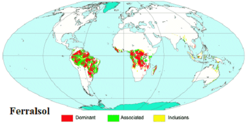
Ferralsol Soils (Lateritic Soils or oxisols)
- Soils of intertropical areas are often referred to as lateritic. However, laterite is a weathering product and not a soil type.
- They are formed on geologically old parent materials in humid tropical climates.
- Most tropical soils are, however, rich in ferric oxide and are collectively known as ferralsols.
- The abundance of sesqui-oxides of iron and aluminium is responsible for the red, brown or occasionally yellow colour.
- Its profile is often very deep, but there is poor horizon differentiation.
- The A horizon makes up the top layer of profile. It is usually acidic with a low humus content.
- The B horizon is predominantly clayey.
- These soils are low in fertility because of the lack of humus and bases.
- Agriculture: Because of the residual metal oxides and the leaching of mineral nutrients, they have low fertility. These require additions of lime and fertilizer. Tree crops such as oil palm, rubber, or coffee are suitable. Pasture is often their main agricultural use after the original forest is cleared.
Distribution
- These are found almost exclusively in tropical areas, in South America and Africa, almost always on highly stable continental cratons.
- Amazon basin अमेज़न बेसिन
- Congo River basin, Guinea, and Madagascar in Africa.
- Indonesia and Malaysia and other southeast Asian countries.
5. Classification of Intrazonal Soils
Hydromorphic soils (Gleysol or Meadow Soils)
- These soils have undergone gleying.

- They are associated with marshes, swamps or poorly drained areas.
- It is a wetland soil (hydric soil) that is generally saturated with groundwater for a long time long enough to develop a characteristic gleyic colour pattern.
- They exhibit a greenish-blue-grey color due to anoxic (low oxygen) wetland conditions.
- On exposure, the iron is oxidized, and the colors are transformed to a reddish, yellow or orange.
- They may be sticky and hard to work.
- Two main types can be recognised according to the position of the water-table in the profile.
- Ground water gleys: where ground water is below the surface; and
- Surface-water gleys.
Distribution

Calcimorphic soils
- Calcimorphic or calcareous soils develop from a limestone parent material.
- Agriculture: cotton, corn and alfalfa crop.
Rendzina soils
- These are thin soils with limited available water capacity.
- These are dark and organic rich.
- Distribution: These are associated with chalk rock in Britain.
Terra rossa soils
- These associated with higher rainfall regions than rendzina.
- It is a predominantly mineral soil. The upper horizons are rich in clay and reddish in colour, sharply contrasting with the parent material.
- Distribution: It is found mainly in the Mediterranean region.
Distribution
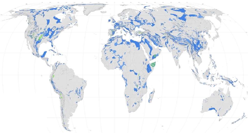

Halomorphic (saline) soils
- Halomorphic or saline soils refers to a soil that has an excessive amount of soluble salts.
- The soil profiles have the predominance of fine particles, which prevents leaching.
- There are high levels of salts. Hence, These soils are reclaimed by leaching of excessive salt concentrations.
- Usara soils are another name for saline soils. There are some regional names like Reh, Kallar, Chopan, Rakar, Thur, and Karl.
- Solanchak (white alkali soils): These develop in depressions. They exhibit white salt crusts in dry periods due to capilary action.
- Solonetz (black alkali soils): These are the product of intense alkalinisation. They are characterised by the presence of sodium carbonate.
- Solodic soils: These develop when leaching causes the loss of clays and sesqui-oxides, forming an eluviated horizon. They look like a podzol.
Distribution
- These are mostly found in deserts.
- These soils can be found in places with high subsurface water tables and canal irrigation.
- In India, these are found in Andhra Pradesh, Karnataka, Bihar, Uttar Pradesh, Haryana, Punjab, Rajasthan, and Maharashtra.
6. Classification of Azonal Soils

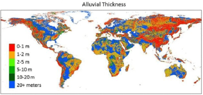
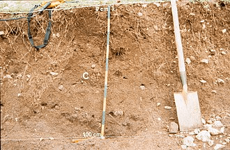
Alluvial soils
- These are developed on active flood-plains.
- Alluvium is loose clay, silt, sand, or gravel that is deposited by running water in a stream bed, on a floodplain, in an alluvial fan or beach, or in similar settings. – Julia Jackson (1997).
- These have little or no profile development, because of the frequent burial under new sediments.
- Floodplain alluvium can be highly fertile. It supported some of the earliest human civilizations.
Geological age:
- Mostly it is of Quaternary age. It is often referred to as "cover", because these sediments overshadow the underlying bedrock.
- Most sedimentary material fills a basin and known as "basin fill". It is not lithified, and is lumped together as "alluvial".
- Alluvium of Pliocene age occurs in parts of Idaho, USA.
- Alluvium of late Miocene age occurs in the San Joaquin River valley, California.
Distribution:
- Northern plain of India.
- Eastern China.
- North East America.
- Southeast Asia except for Indonesia and Malaysia.
- Estuaries and coastal areas.
Regosols
- These are composed of dry and loose sand dunes or loess. Wind is the main factor.
- It is very weakly developed mineral soil in unconsolidated materials.
- Land use of regosols varies widely. Some Regosols are used for capital-intensive irrigated farming. The most common land use is low volume grazing. Regosols in mountain areas are best left under forest.
Distribution
- Found extensively in eroding lands, in particular in arid and semi-arid areas, dry tropics and mountain regions.
- Found in all climate zones without permafrost and at all elevations.
Lithosols
- These are accumulations of imperfectly weathered rock fragments on steep slopes, where erosion rates remove soil almost as fast as it is formed. Hence, a permanent covering of deep soil cannot establish itself.
- Gravity is the main factor.
- These are exceedingly shallow soils. They are often referred to as skeletal soils.
Distribution:
- These soils occur in almost all regions of the world where steep slopes are prevalent.
- Tibetan plateau.
- Himalayan region.